The Great Map
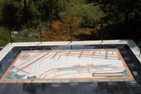
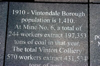
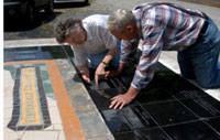
Our Great Map Project, a large mosaic inspired by the original 1923 Sanborn Insurance Map of the Vinton Colliery, overlooks the wetlands, linking the humanities and the arts in its visual and interpretive power. Standing upon the map, visitors can locate and compare the present landscape and buildings to those of the mining times. The eighteen-by-twenty-two-foot platform holds a nine-by-fifteen-foot mosaic and is located across from the former entrance to the Mine No. 6 Portal and immediately adjacent to the Ghost Town Rail Trail. Framing the map are 131 granite tiles, fifty-four of which are laser-etched with community images, newspaper headlines and text. The word "hope" has been translated into twenty-six of the languages once spoken in Vintondale. Visitors and residents alike now have the opportunity to recognize, understand, and reflect upon Vintondale's rich community history, an area often overlooked in mining towns.
| Funding |
Funding for this part of the Vintondale AMD&ART Remediation System came from the funding sources noted in the documents below.
Documents are available in PDF format, viewable in the free Adobe Reader, and in Microsoft® Word format. |
All Rights Reserved • AMD&ART 2003 – 2016 • Email: [email protected]


